Document Actions
Land - State and impacts (SOER 2010)
The state and impacts, including impacts on the natural environment and human health/human well-being of land-use in Belgium
The state and trends regarding land are assessed hereunder with two indicators: the land cover composition at the national level and the share of built-up areas in the three regions.
Land cover composition in Belgium
Key message
Steady increase in built-up area at the expense of agricultural land in Belgium
Figures
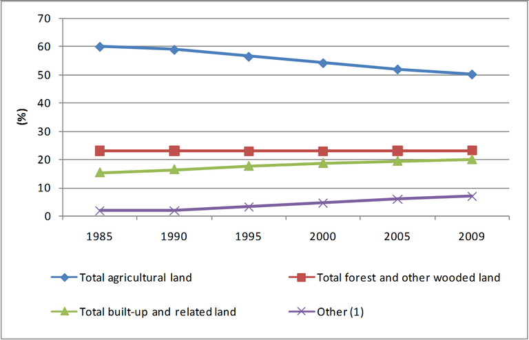
Figure 1: Share of the various types of land use in the total soil area in Belgium, 1985-2009
- Data source
- http://statbel.fgov.be/fr/modules/publications/statistiques/environnement/utilisation_du_sol.jsp
- http://statbel.fgov.be/nl/modules/publications/statistiques/environnement/utilisation_du_sol.jsp
Fullscreen image Original link

 wet open land, dry open land with special vegetation cover and open land without or with insignificant vegetation cover")
During the last 25 years, the share of built-up and related land has increased, from 15 % in 1985 to 20 % in 2009. It represents an annual growth rate of 1.1 %. This growth in built-up and related land has been mainly at the expense of agricultural land, which decreased from 60 % to 50 %. The forest and wooded land has remained stable, at about 23 %.
Although the proportion of rural areas remains fairly high (80 % of agricultural land, woodland and other land), widespread urbanisation and transport infrastructures are breaking up the land into a larger number of subdivided areas. The sealing of natural soils also influences the hydrological status: water can no longer infiltrate and instead runs off via the paved surface. Because of this, flooding risk is increasing. Moreover, the open space becomes fragmented and this fragmentation causes, among other things, spatial isolation and the reduction of the habitats of fauna and flora. It hereby places additional pressure on the biodiversity.
Share of built-up area in the 3 Regions of Belgium
Key message
Increase in the share of built-up area in the 3 Regions, which show however different urbanisation profiles
Figures
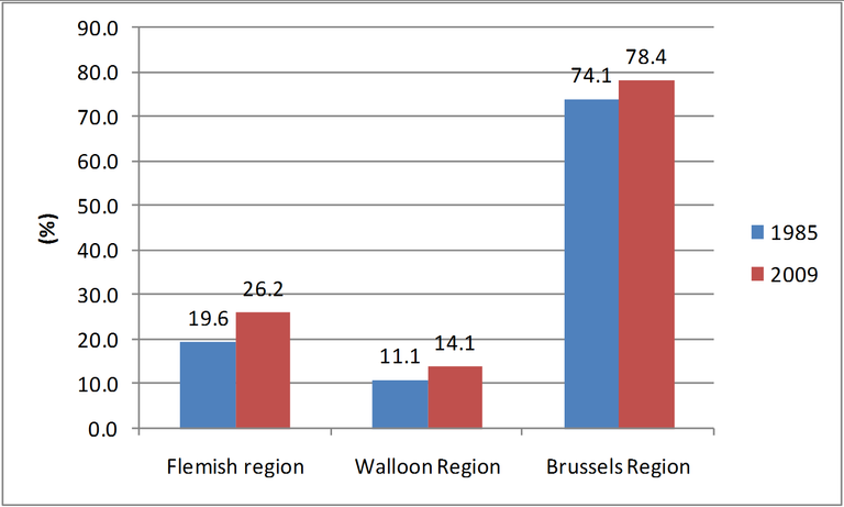
Figure 2: Share of built-up area in each Region of Belgium, 1985 and 2009
- Data source
- http://statbel.fgov.be/nl/modules/publications/statistiques/environnement/utilisation_du_sol.jsp
- http://statbel.fgov.be/fr/modules/publications/statistiques/environnement/utilisation_du_sol.jsp
Fullscreen image Original link

The shares of built-up area have increased in each region between 1985 and 2009, but the level of these shares is different. The Brussels-Capital Region, being a strongly urbanised area (6,497 inh/km2), has the highest share of built-up area, with 78.4 % of its territory covered by residential and commercial buildings, public infrastructure, transport infrastructure, etc. This figure has yet to be put into perspective since it includes for instance private gardens and recreational and other open land (e.g. major public parks, green areas and sport fields). However, a study estimated that in the Brussels Region, the average rate of sealed surfaces amounts to about 47 % (2006)1. The Flemish Region also presents a high share of built-up area, with more than a quarter of its territory covered by built-up area, and has a high degree of sealing, with 186,000 ha or 13.8 % of the Flemish soil sealed2. In the Walloon Region, the built-up area reached 14.1 % and the estimated proportion of sealed surfaces is much lower, as it represents only 2.6 % of the Walloon territory (44,250 ha)3. In 38 Walloon municipalities (out of 262), urban area has more than doubled compared with 19804. However, Wallonia has a large share of its territory covered by forest and wooded land (about 30 %) which has remained constant during the last twenty years.
1 Bruxelles-Environnement, rapport sur l’état de l’environnement 2003-2006 sur base d’une étude de VANHUYSSE S., DEPIREUX J., WOLFF E. 2006. « Etude de l’imperméabilisation du sol en Région de Bruxelles-Capitale », étude réalisée par l’ULB-IGEAT pour le Ministère de la Région de Bruxelles-Capitale, AED – Direction de l’eau, octobre 2006.
3 Direction Générale de l'Agriculture, des Ressources Naturelles et de l'Environnement - Service Public de Wallonie. Rapport analytique sur l'état de l'environnement wallon 2006-2007 (SOLS6 : L'imperméabilisation et la compaction des sols)
